Soil Sensor Teaching Tool

Soil sensor equipment has been installed at the Sustainable Agricultural Systems Unit (SASU), including the Agroecology Education Farm, Fike Agronomy Field Lab, and Beef Pasture Unit. This project aims to provide a teaching tool based on area-specific and real-time information that instructors use to teach students concepts and processes of water movement through a soil profile.
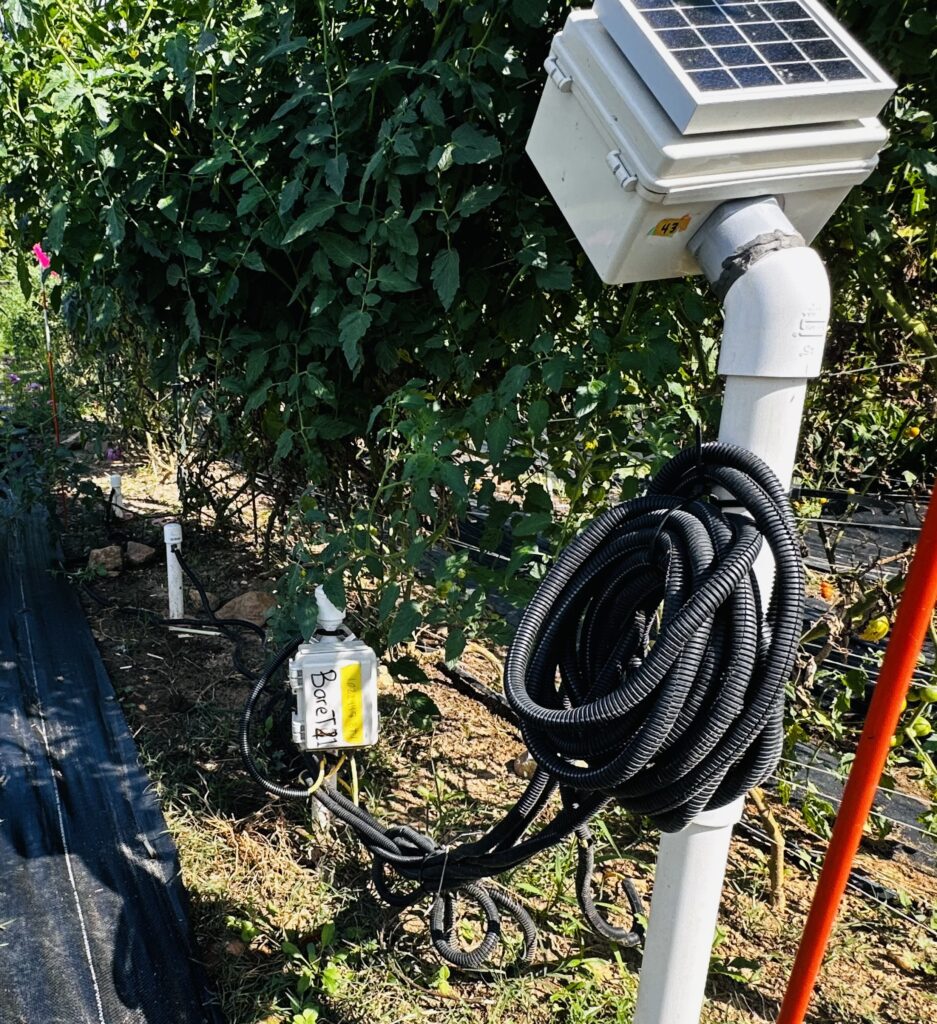
With the help of the Precision Sustainable Agriculture lab, we have installed Acclima Inc. equipment throughout the SASU. We are using the Acclima True TDR-310H Soil Water Content Sensor with cylindrical form factor along with Acclima Nodes and Gateway Access. There are several data types collected from the probes:
Water Content (Percentage)
Soil Temperature (Celsius)
Permittivity (learn more here)
Bulk Electrical Conductivity
Pore Water EC
There are 4 sensors connected to each node measuring at 2, 10, 20, and 30 inches below the soil surface.
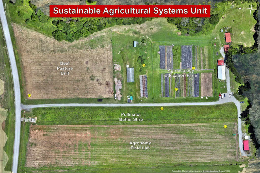
The node locations are indicated on the map below in yellow. The 6 nodes represent a gradient of land management. The nodes are in the Food Forest and two vegetable beds of the Agroecology Education Farm, the Beef Pasture Unit, the Pollinator Buffer Strip, and the Fike Agronomy Field Lab.
The primary soil type at SASU is a Wedowee Sandy Loam with a 6-10 percent slope. Soil sample data from February 2025 is also available upon request.
The vegetable beds in the Agroecology Education Farm are organically managed and are a reduced-till production space. The farm was previously managed as a no-till facility for years prior, but was transitioned back into conservation tillage 2 years ago. Amendments added into the soil include routine compost additions from the compost facility before planting a new crop, poultry litter fertilizer (5-4-3) before planting, chicken feather or blood meal occasionally, as well as sulphate potash occasionally. Fish emulsion fertilizer is added through drip irrigation occasionally. Block 6 is typically managed as vegetable production using landscaping fabric between rows. Prior crops in that area include cotton, followed by a winter cover crop. Block 3 has been in perennial herb production for 1.5 years with landscaping fabric between rows. Prior to the herbs it was planted with pumpkins, followed by a winter cover crop.
The Food Forest in the Agroecology Education Farm contains perennial edible trees and shrubs and has been in place since 2021 (4 years). The production space has received no tillage since planting. There are high levels of organic matter present here, providing an opportunity to demonstrate the effects of organic matter within the soil profile. This could be partly attributed to the integration of hügelkultur principles in the food forest planting and the addition of compost and woodchips afterwards.
The Beef Pasture Unit undergoes rotational grazing, typically around once every 2 months. It is planted with winter and summer annual grazing mix.
The Pollinator Buffer Strip serves as the mandatory land strip between non-organic production and organic production to prevent spray drift. It is currently planted with a mix of native and non-native perennial pollinator plants that appeal to a wide variety of pollinators in the area. The field is occasionally disked to reduce weed pressure (every few years). It undergoes a controlled burn, typically in the fall of each year.
The Fike Agronomy Field Lab is an unirrigated, non-organically managed row crop field that has been mostly fallow for most of the past two years (2023-2025) and has been subjected to high weed pressure. Before remaining fallow, the field had been in field crop production for the past decade, mostly silage corn, cotton, and fiber hemp. The field had been tilled parallel to the slope (N-S direction) at this time. This included annual moldboard plowing in addition to secondary tillage operations for seedbed preparation. During the latter years of field crop production, tillage intensity was reduced, and cover crops were planted after the summer annual crop was removed. Crop residue is left on the field. It undergoes regular disking between crop plantings to reduce weed pressure. Weeds are managed with chemical weed control, as needed, and cover crops are terminated chemically with herbicides.
There are many possible applications in the classroom that could include calculating soil percolation through the soil profile, comparing soil layer temperatures, or using the information in conjunction with other data. For example, a soil management study may be interested in how the soil water content changes between different soil management zones or soil textures. A crop physiology study may be interested in the relationship between soil moisture content over time and crop performance through its growing cycle. A soil fertility study may be interested in the relationship between soil test data, field history, and soil EC data over time. An ecology class may be interested in the relationship between species presence in the pollinator buffer strip and soil water content over time. The information provided by this project allows for creativity and flexibility in its application, encouraging both inter-departmental and intra-departmental collaborations.
If you are interested in gaining access to this teaching tool, please contact the Lab Coordinator. Use this link to the instructions after being granted access.